Healthier Fields | Sky-High Yields
Precision Crop Solutions
Step 1: Know the Problem
Step 2: Better Solutions
Step 1: Know the Problem - Crop Assessment
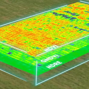
Often, the problem is invisible, especially in the early stages. We use multispectral imaging to see more than what the naked eye can see.


The DJI Mavic 3M combines a 20 MP RGB camera with four multispectral cameras (green, red, red edge, and near infrared). This enables high-precision aerial surveying, crop growth monitoring, and natural resource surveys.
Whether from pest, weeds, or drought, the Mavic 3M reveals changes and abnormalities in the field at the centimeter-level. It allows farmers to make smarter decisions because they see problems differently.
With these prescription maps, especially regarding nitrogen levels, our agricultural drones can use variable-rate application to reduce costs, increase yield, and protect the environment.
NDVI - Normalized Difference Vegetation Index
General vegetation health
Ideal for early-stage crops
GNDVI - Green Normalized Difference Vegetation Index
Monitors nitrogen uptake
Detects stress
LCI - Leaf Chlorophyll Index
Measures chlorophyll content
Monitors nitrogen uptake
NDRE - Normalized Difference Red Edge Index
Monitors nitrogen levels
Best for mid- to late-stage crops
OSAVI - Optimized Soil-Adjusted Vegetation Index
Enhances vegetation signals
Useful in areas with sparse vegetation
Looking For a Leg Up?
The optimal frequency for farmers to scan their fields using multispectral imaging depends on several factors. Scanning fields frequently can provide timely data to monitor crop health, make informed decisions, and develop prescription maps specialized to each field's conditions. It allows for:
Early detection of crop stress.
Timely interventions.
Tracking crop development.
We developed plans tailored to a crop's needs and growth stage.

Step 2: Better Solutions - Precision Spraying
Spraying cropland at 50 acres/hr and orchards at 10 acres/hr, the DJI T50 is capable of maximizing the data from the Mavic 3M to increase your efficiency and meet your spraying or spreading needs.
Our DJI T50 maximizes yield and minimizes product waste through precision spraying. It adjusts to inclines and declines, changing its speed and altitude to maintain uniform spreading. This is THE solution for wet ground, prairies, uneven terrain, or just buying you back time for other pressing issues.


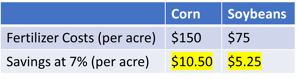
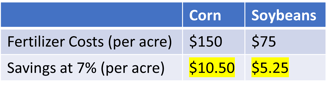
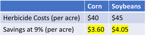
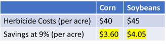
Savings Using Drone Spraying
How much could you save?
Like all things, it depends. Let's focus on just fertilizer and herbicide.